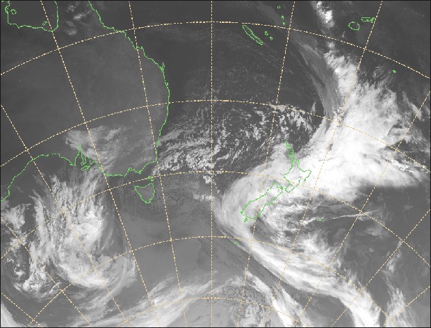
If you thought last week’s storm cycle in New Zealand was big then look out as this week’s weather descends upon the Canterbury and MacKenzie snow fields. Big doesn’t begin to describe it.
New Zealand skiers and snow boarders are salivating right now as a critical weather incident hits up the South Island with forecasts of over a metre of snow in some ski areas. This is hot of the heels of the metre snow storm last week.
“It’s not letting up! My Hutt is set to receive more that 1.2m of snow by tomorrow evening, while on the flat expect significant rainfall, as a general rule heavier south of Christchurch. Snow lowers to 500m for a time tomorrow.” Canterbury Snow and Weather watch
Heavy snow is expected in Mackenzie areas (Dobson, Roundhill, Fox Peak) including the town of Tekapo with over a metre on the cards.
Extreme winter event
Both Canterbury Snow and Weather Watch and Canterbury Weather Updates are calling this storm one of the most extreme winter events in years with gale force winds and torrential rain below 300 to 400 meters above sea level. Flooding is expected in valley areas and snow laden roads in the higher areas will no doubt be closed.
“This is a major winter storm; in fact currently it’s potentially one of the most severe looking set-ups we’ve seen in a number of years.” Canterbury Weather Updates.
Well over a metre of snow is expected above 1300 meters. However there will also be glass in some areas with gusts up to 100 kilometers per hour in exposed areas.
The North Island ski areas will also be impacted with over a metre of snow forecast for Mt Ruapehu. Further south in Otago there will be a mix of rain and snow at the Queenstown and Wanaka ski areas. Freezing level will be around 1400 meters.
The New Zealand Met Service issued a severe weather warning on their website:
“This is a significant weather event and the combination of heavy rain and strong winds expected to cause widespread disruption to transport, localised flooding and slips. Also in the South Island, wind chill due to cold temperatures and strong winds could cause stress to livestock.
People in these areas are strongly advised to stay up to date with the latest forecasts as this event unfolds in case more areas are added to this WATCH or parts of this WATCH are upgraded to a full WARNING.”

Avalanche warnings
After last week’s major snow event, the upcoming snow fall is set to contribute to some serious avalanche concerns. Ski patroller, Charlie Lyons from Mt Olympus issued these warning words yesterday.
“I have just finished a meeting in Flock hill with all heli ops in canterbury, guides, patrol teams from all resorts, police, Westpac, land sar and doc and thought it would be paramount to pass on some very important info.
We are facing some of the worst avalanche conditions in nearly 20 years.
Throughout the Two Thumbs, Mt Hutt range, Arrowsmiths, Grey Range, Cragieburns and Arthur Pass we have a very reactive persistent instability on all aspects above 1600m but can be found as low as 1400m through the Mckenzie country.
This layer ranges from 20cm deep to up to 3m in some location. These facets are forming above and below a rain crust that is now buried by the July 11-14th storm series.
Recent warming has done very little to help heal these issues in fact it’s actually insulated them further with wind slab forming Lee NW 1/2. Guide Anna Keeling remote triggered a class 3 and 2 yesterday in the side country of Porters.
This weekend we will see an additional load of up to 1.5m in start zones, possibly more, this will tip the entire pack into an natural avalanche cycle. There was talk of these facets remaining well into August or until we see a very significant warming/100mm of rain. Given this weeks storm these facets will be insulated further.
We have all lost friends in the mountains, we all know how much that can hurt so please all heed the signs and know that there is plenty more time to find good skiing. Please take the responsibility to pass on and help get the word out, it’s possibly not what you will do but others.”
Mark these websites
Bookmark these sites to monitor the storm impact and snow fall as the storm progresses.
New Zealand Avalanche Advisory
Stay safe out there people.


