There’s a lot of talk about that much needed snow storm heading our way next week. But where is it going to snow, when and how much?
Waiting for a taxi in the streets of Paddington in Sydney on a Saturday night after a lost Wallaby test feels more palatable right now than waiting for the snow we are yet to have. I feel like we’ve been all dressed up in our ski gear for weeks now with nowhere to go. But don’t remove that ski jacket just yet, word on those streets is natural snow is on it’s way to boost the exceptional snow making efforts of the resorts thus far.
Australia has some ‘go to’ forecasting sites that amateur meteorologists fawn over throughout winter hoping to find the next big snow system to bring the powder storm of the decade or just the season. Victoria’s favourite meteorologist Jane Bunn has proven over the years to be one of the most accurate forecasters in the snow world. In her own words on her website (bookmark it now) she says:
“A bigger system moves through next week, with snow due each and every day. This has a slow-moving cut-off low, allowing several fronts to pass through, and a small feed of tropical moisture left over from this week’s inland rain. It puts us in a generally westerly airflow for a long time – great for accumulating snow at the major resorts.”
Her prediction for snow within the next eight days? Jane’s calling 63cm at Perisher, 56 at Thredbo, 61cm at Falls Creek, 50cm at at Hotham and 36cm at Buller.
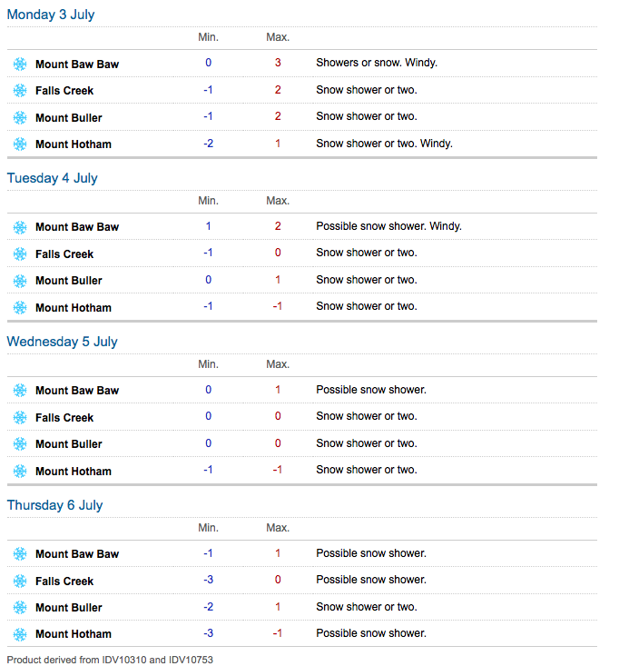
The Bureau of Meteorology (BOM) has only forecast in the Snowy Mountains New South Wales until Monday July 3. Though they are calling for showers falling as snow above 1400 metres on Monday. In Victoria the BOM forecast looks far more hopeful (see below).

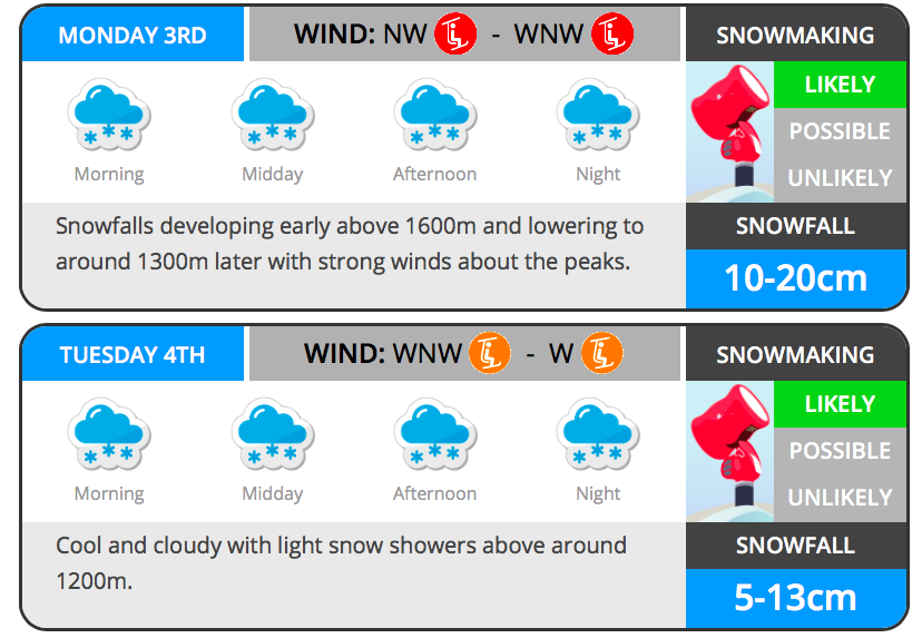
Pete ‘The Frog’ Taylor over at Snowatch.com.au is also saying Monday and Tuesday are the days to look out for powder falling from above.

Weatherzone.com.au are calling for over 20cms to fall – “The first week of July is looking rather snowy due to the likelihood of a series of decent cold fronts. This looks like becoming one of our snowiest weeks of the season so far with more than 20cm a good chance, most falling during Monday/Tuesday.”
I’m an optimist. I prepare for the best which yes, means I am often disappointed, but also means I am ‘right’ when forecasts like Jane’s come through and I guess I like the idea of being ‘right’ more than I like to be disappointed. So, here’s to half a metre by this time next week. Bring on Monday and Tuesday.


